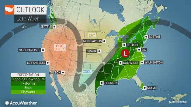
AccuWeather map, 4/27/21.
SIOUX FALLS, S.D. (KELO.com) — High temperatures soaring to levels more typical of June will put some long-standing records in jeopardy across the Ohio Valley and mid-Atlantic, but forecasters say the summer preview will come to an abrupt end as the calendar flips to May.
The core of the warmth was felt across the central Plains Monday, with Omaha, Nebraska, cracking the 90-degree Fahrenheit mark for the first time this year and falling just 3 degrees shy of its daily record of 95. Chicago soared to 79 for Monday’s high, a stark contrast to the chilly end to this past weekend when temperatures peaked in the upper 40s.
Chicago will continue to heat up Tuesday, and areas farther east will also get in on the taste of summer. Similar to Monday, high temperatures may come up just short of achieving record status but will still climb well into the 80s, or 10-20 degrees above late-April normals.
Temperatures will also begin their ascent in the Northeast Tuesday, following a seasonably cool start to the week, but forecasters say the warmest air will still be yet to come for this part of the country.

“Wednesday is expected to be the warmest day of the week,” AccuWeather Senior Meteorologist Carl Babinski said.
In fact, the middle of the week could bring the warmest weather of the year so far for portions of the mid-Atlantic.
Washington, D.C., will approach the 90-degree mark and challenge the record for the day of 92 set back in 1957. Baltimore will also make a run at 90, which is the record for the day. The highest thermometers have risen in Baltimore and Washington, D.C., so far this year is 83 and 84, respectively, back on March 26.

Farther north, New York City may match its warmest day yet this year on Wednesday after reaching 82 on March 26.
In Columbus, Ohio, Wednesday’s projected high of 82 would fall just 3 degrees shy of the city’s daily record of 85 from 1914.
These temperatures are 15-20 degrees above normal for late April, and closer to what is typical for later in June, according to AccuWeather Meteorologist Jake Sojda.

Coastal areas will also get a taste of the summer warmth, as forecasters expect enough of a breeze coming from the land to keep any sea-breeze effects at bay. Rehoboth Beach, Delaware, will near 80 at midweek, while Atlantic City, New Jersey, is projected to climb into the lower 80s.
However, forecasters say to think twice before taking a dip in the Atlantic Ocean or an inland lake, river or stream. Water temperatures remain cold coming out of the winter months, due to the fact that it takes water much longer to heat up than the air.
Entering the chilly water this time of the year can lead to cold water shock.

“Typically, in the spring and early summer is when people start venturing out onto the water and [they] don’t quite realize what they’re getting into with how dangerous the cold water is,“ Keith Bills, a course manager at the National Ice Rescue School for the Coast Guard previously told AccuWeather.
Any water at or below 77 is considered to be cold water, and the lower the temperature, the quicker it will begin to affect the body.
As of Monday, April 26, water temperatures along the upper mid-Atlantic coast were generally in the 50s.
Residents who head outside to soak up the warmth will need to keep a close watch on the sky in part of the region Wednesday.
An advancing storm system will clash with the warmth and trigger areas of showers and thunderstorms across the interior Northeast, especially during the afternoon hours. A few of the storms across New York state and into northern and western Pennsylvania and Ohio could contain locally damaging winds, along with torrential downpours.
This wet weather will mark the start of a downward trend in temperatures, according to forecasters, but not before a rather mild Wednesday night.
“Low temperatures Wednesday night are expected to be in the 60s in many places, which is the kind of thing you’d expect to see late in June, and not during the tail end of April,” Babinski said.
More widespread rain and thunderstorms are expected for the latter half of the week, which will play a key role in trimming daytime temperatures Thursday and Friday. The wet weather will be associated with the same system set to first unleash severe weather and flooding downpours across the Central states late Tuesday into Wednesday.
Behind this system, temperatures may settle several degrees below seasonable levels for the start of May Saturday, with highs in the 50s and 60s expected.
( AccuWeather meteorologist, contributed this report.)


