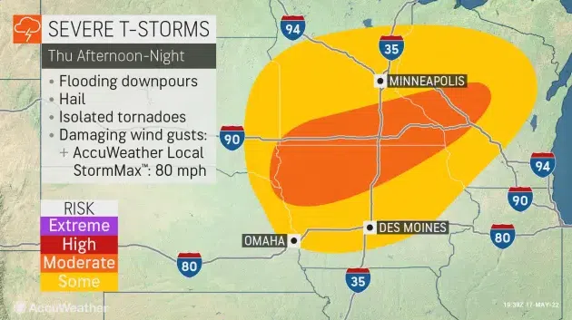
AccuWeather.com map, 5/18/22.
SIOUX FALLS, S.D. (KELO.com) — Following destructive thunderstorms that tore through portions of the Central states last Thursday, AccuWeather forecasters are monitoring the next potential round of severe weather in a similar area.
Tranquil weather was in place across the northern Plains and Upper Midwest for days, but the silence was broken in part of the Plains when thunderstorms with high winds and large hail broke out on Tuesday. The zone of storms will shift east and pose a flood threat on Wednesday.
Meanwhile, a few storms could develop in Minnesota and western Wisconsin on Wednesday.

However, a much more widespread threat of severe weather is expected on Thursday.
“The most notable period of severe weather will begin on Thursday from northeastern Nebraska to northern Wisconsin,” said AccuWeather Meteorologist Andrew Johnson-Levine.
He added that hail, damaging winds, flooding and tornadoes will all be possible. This is an area of the country still trying to recover from last week’s storms.
“Many of these areas were recently hit by destructive winds from last week’s derecho, and may be more vulnerable than normal to severe weather,” explained Johnson-Levine.
Structures and trees that may have been compromised by last week’s storms could be more susceptible to additional damage if they are already in a weakened state. However, this event is not expected to come anywhere close to the intensity and magnitude of what occurred one week ago. Additionally, the worst of the storms should be slightly to the east of where the worst damage was sustained last week.
Residents and motorists traveling along interstates 35, 80, 90 and 94 will need to be wary of ponding and reduced visibility due to heavy rain.
The severe threat will end in the Upper Midwest on Friday, but the risk will shift farther east. Not only will the zone shift eastward, but it will also extend much farther south.
“Intense thunderstorms may fire over a broad area of the central U.S., stretching from Texas to Michigan,” said Johnson-Levine.
The tornado threat will be very low on Friday, but flooding downpours, hail and damaging wind gusts will again be concerns. Chicago, St. Louis and Dallas are just a few locations that may have severe weather on Friday.

Johnson-Levine noted that the risk on Friday will be fueled by a potent jet stream and a surge of heat and moisture from the Gulf of Mexico. This heat and moisture will expand northward ahead of a cold front.
The cold front will continue to progress eastward over the weekend. Some locations in the Northeast may experience the highest temperatures so far this year before the front arrives.
“Fueled by heat more typical of July than May, severe weather may continue farther east this weekend,” said Johnson-Levine.
By early next week, storms may be focused primarily over Kansas, Oklahoma and Texas. This may deliver some desperately needed rain even in the western portions of those states, which are in an extreme to exceptional drought according to the United States Drought Monitor.
( AccuWeather meteorologist, contributed this report. It first appeared here on Accuweather.com.)