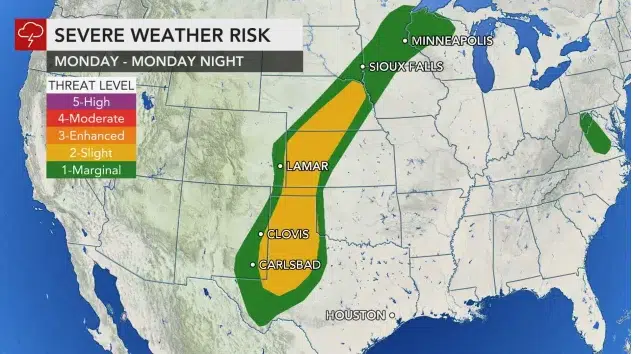
The map above is based on the National Weather Service Storm Prediction Center (SPC) convective outlook, which highlights the risk for severe thunderstorms. Map from AccuWeather, 5/24/21.
SIOUX FALLS, S.D. (KELO.com) — The National Weather Service confirmed a total of nine tornadoes in Colorado on May 22.
In the wake of an active weekend for severe thunderstorms and tornadoes across the High Plains, AccuWeather meteorologists say that the weather pattern will remain conducive for more rounds of feisty storms over the nation’s midsection into midweek.
The corridor from New Mexico to South Dakota was lit up by thunderstorms which produced large hail, damaging winds and tornadoes on Saturday and Sunday. Hail larger than baseballs pounded Sunol, Nebraska, to end the weekend.

In Colorado, eight tornadoes were confirmed Saturday with several more spinning up Sunday. Fortunately, most of the tornadoes swirled harmlessly over open land, providing an ideal setup for storm chasers to capture unobstructed video footage from a safe distance. Tornadoes were also reported in Perkins County, South Dakota, to end the weekend.
Forecasters say that storm systems ejecting out of the Rockies will continue to provide the energy needed to ramp up thunderstorm activity daily across the Plains.
Rounds of spotty severe storms are forecast to continue to rumble to life across portions of the Plains each day through at least Tuesday night, according to AccuWeather Meteorologist Mary Gilbert.
Severe weather dangers will shift focus largely out of Colorado and instead take aim farther to the east.
CLICK HERE FOR THE FREE ACCUWEATHER APP
From Monday evening through Monday night, a corridor from eastern New Mexico and West Texas to the Oklahoma Panhandle, Kansas and Nebraska will be at greatest risk for the severe storms. Midland, Lubbock and Amarillo, Texas; Garden City, Dodge City and Colby, Kansas; and Grand Island, Nebraska, could be impacted by the storms.
AccuWeather’s expert team of severe weather forecasters in Wichita, Kansas, anticipates that damaging winds, large hail, torrential downpours and isolated tornadoes will all be hazards.

This graphic shows were AccuWeather forecasters believe the highest risk for severe thunderstorms and isolated tornadoes could occur.
Wind gusts to an AccuWeather Local StormMax™ of 80 mph in the most severe storms can lead to power outages and tree damage in some communities, but even motorists will want to take note of this hazard. Such winds are strong enough to blow over high-profile vehicles on the open highway.
A more localized area of gusty storms is also possible farther north late Monday across the upper Mississippi Valley.
Motorists should be ready to slow down when they encounter downpours while driving on the highway, as there can be ponding of water on the roadway that increases the risk of hydroplaning. In addition, visibility can be rapidly reduced.
On Tuesday afternoon and night, downpours and severe storms are likely to set up along a similar zone from the southern Plains to portions of the upper Mississippi Valley.
There may be a slightly lower risk of widespread severe weather this day, depending on how much cloud cover and rain lingers from Monday night. Regardless, forecasters cannot rule out the potential for storms to produce hail and damaging wind gusts, along with torrential downpours.

“Anyone living in the impacted areas should be sure to have multiple ways to receive important weather warnings for their specific location, like the AccuWeather app,” Gilbert said.
The rainfall across the central Plains and Midwest will prove to be very beneficial as many spring crops are emerging across the region, according to AccuWeather Long-Range Meteorologist Brandon Buckingham.

Portions of the Midwest could use a thorough soaking, with abnormally dry to severe drought conditions being reported in Iowa, Minnesota, Wisconsin, Illinois and Michigan, according to the United States Drought Monitor.
Farther south, however, any additional downpours could quickly exacerbate flooding problems in the soaked South Central states.
While most of the severe thunderstorms will stay west of the hardest-hit areas of eastern Texas and southwestern Louisiana, locally heavy downpours streaming in from the Gulf of Mexico will pester these areas through early week.

The severe weather hits will keep coming, according to forecasters, with yet another round of violent thunderstorms forecast across the Plains at midweek.
( AccuWeather meteorologist, contributed this report.)