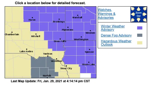
SIOUX FALLS, S.D. (KELO.com) — The Sioux Falls metro is under a Winter Weather Advisory issued by the National Weather Service from midnight Friday night to midnight Saturday night.
Areas west and south of the Sioux Falls metro will be under a Hazardous Weather Outlook.
Portions of northeast Nebraska will be under a Dense Fog Advisory.
From the NWS for the immediate Sioux Falls area:
…WINTER WEATHER ADVISORY IN EFFECT FROM MIDNIGHT TONIGHT TO MIDNIGHT CST SATURDAY NIGHT…
* WHAT…Freezing drizzle and light snow expected. Total ice accumulations of up to one-tenth of an inch and snow accumulations of up to one inch.
* WHERE…Portions of east-central and southeast South Dakota, northwest and west-central Iowa and southwest Minnesota.
* WHEN…From midnight tonight to midnight CST Saturday night.
* IMPACTS…Very slippery sidewalks, roads, and bridges are possible.
* ADDITIONAL DETAILS…The greatest impacts from this system will be due to freezing drizzle, which will create a glaze of icing before light snow begins late in the day Saturday.
* PRECAUTIONARY/PREPAREDNESS ACTIONS… Slow down and use caution while traveling. The latest road conditions for the state you are calling from can be obtained by calling 5 1 1.


Comments