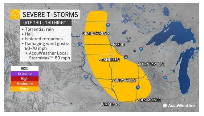
AcuWeather.com map, 7/14/22.
SIOUX FALLS, S.D (KELO.com) — The Upper Midwest was relatively quiet on Wednesday after spotty severe weather on Tuesday, but AccuWeather meteorologists say that break will be short-lived.
A persistent and familiar pattern that has been in place so far this summer has featured excessive heat in the southern Plains and frequent showers and thunderstorms in the northern Plains and Upper Midwest. The heat continued unabated on Wednesday, but there was a brief break in the storminess farther to the north. However, the first signs of the next round of storms were already on the horizon.
“A dome of high summer heat will continue to dominate the central and southern Plains throughout the next several days, and strong and gusty thunderstorms will erupt along the northern rim of that heat,” explained AccuWeather Senior Meteorologist Mike LeSeney.
The drought once firmly in place across the northern Plains has been trimmed away following a wet spring and stormy summer. To the south and east, rounds of showers and thunderstorms have been a bit less frequent, allowing drought to persist. Beneficial rain could return to these drought-stricken areas, but the risk of severe weather will accompany it.
“A front sliding through the Dakotas on Thursday afternoon will set the stage for a severe storm event in the north-central Plains and Upper Midwest into Thursday night,” said AccuWeather Meteorologist Adam Sadvary.
Thunderstorms are not expected to develop until around sunset Thursday. A few storms will form in eastern North Dakota before diving southward into northeastern South Dakota and western Minnesota. As the storms move south, they will expand in coverage and strengthen.
“Abundant energy in the atmosphere will allow the storms to be capable of producing damaging wind gusts and heavy downpours, but hail and even an isolated tornado are not out of the question,” said Sadvary.
Strong storms that develop late on Thursday are likely to persist well into Thursday night and into Friday.
“The complex of rain and thunderstorms is forecast to travel southeastward into southern Wisconsin and northern Illinois by Friday morning along the burst of energy in the atmosphere,” noted Sadvary.
Although the storms will continue into Friday, they should lose some of their intensity.
“Most of the remaining storms on Friday are not expected to produce severe impacts, but pockets of heavy rain can cause localized flooding from Milwaukee and Madison, Wisconsin, to Chicago,” said Sadvary.
While widespread thunderstorms are not likely in the Midwest on Friday, attention will turn to the High Plains, where the next complex of thunderstorms is forecast to unfold.
Spotty thunderstorms will fire up late Friday from southern Saskatchewan in Canada southward through Wyoming. These storms may attempt to form into a more solid line as they travel eastward into the western Dakotas and the panhandle of Nebraska on Friday night. Yet again, downpours and damaging wind gusts will be the main threats, but the storms in the northern portions of the threat zone may also contain hail.

The severe threat may lower somewhat on Saturday, but the strongest storms may have some gusty winds or hail in the Dakotas.
Looking ahead to the weekend, wet weather could disrupt travel and outdoor plans as rounds of rain and thunderstorms return to the Midwest, including areas around Minneapolis; St. Louis; Indianapolis; and Grand Rapids, Michigan. Even though rain will become a bigger concern, gusty winds and hail are still possible with the stronger thunderstorms.

Much of the region should finally get a multi-day break from the unsettled pattern by early next week. The one exception may be areas near the Canadian border, but a drier regime is expected farther to the south.
With less shower and thunderstorm activity expected, temperatures will return to above-normal values, especially in western locations. Parts of South Dakota may be over 100 degrees Fahrenheit as early as Monday.
( AccuWeather meteorologist, contributed this report. It first appeared here on AccuWeather.com.)


Comments