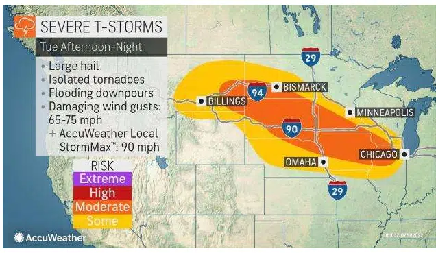
AccuWeather.com map, 7/5/22.
SIOUX FALLS, S.D. (KELO.com) — Intense thunderstorms could elevate the risk of power outages for millions across the central U.S. through midweek, including the potential for a particularly dangerous complex of storms known as a derecho.
Thunderstorms will rumble from Montana to Maryland early this week with all modes of severe weather possible.
AccuWeather forecasters say summer heat will continue to set the stage for damaging thunderstorms this week as millions of residents find themselves in the path of potent storms for several days in a row.
“The weather pattern that will spawn a multiday thunderstorm risk is in response to a rather peculiar jet stream setup,” AccuWeather Meteorologist Brandon Buckingham explained. “A potent storm forcing cool air into the Northwest will clash with a dome of high pressure anchored over the Plains, setting the stage for thunderstorms to erupt.”
On Tuesday, severe thunderstorms are forecast to rumble to life across a large swath of the United States. Residents from the northern Rockies to the Midwest will need to keep an eye to the sky for rapidly changing conditions as the day progresses.
Forecasters expect thunderstorm development to begin by Tuesday afternoon across portions of Montana and the Dakotas. Throughout the day, these thunderstorms are expected to become more intense as they track southeastward across the Plains. Storms could disrupt motorists traveling home following the extended Independence Day weekend, including along stretches of interstates 29, 90 and 94.
These thunderstorms are expected to erupt along the northern edge of a robust area of heat, sometimes referred to as a heat dome. This area of heat continues to bake portions of the South Central states.
As storms push across the Plains during the afternoon and arrive in the Midwest by the evening hours, thunderstorms may congeal into lines or clusters. When storms merge into a large, organized group, it ramps up the threat of damage that is more widespread in nature, rather than localized to a few locations.
“One of the unique aspects of this type of severe thunderstorm setup is that the threat for wind damage is much more widespread than what typically occurs with most severe thunderstorms,” AccuWeather Meteorologist La Troy Thornton explained. “Typically, severe thunderstorm wind damage tends to be much more localized to a part of a community, whereas this cluster of thunderstorms may create widespread damage over a much larger area.”
AccuWeather forecasters say widespread wind gusts on the order of 65-75 mph are likely with an AccuWeather Local StormMax™ of 90 mph.
Wind damage of this magnitude is more likely to raise the risk for significant, long-lasting power outages.
If wind damage occurs from the same complex of storms over hundreds of miles, it may be considered a derecho. A derecho is a storm complex that causes damage continuously or intermittently for 400 miles or more along a 60-mile-wide or more swath, according to the Storm Prediction Center (SPC).
Recent derechos have caused extreme damage in the U.S. A recent notable example is a derecho that caused widespread destruction across Iowa in August 2020, decimating fields of crops with wind gusts up to 140 mph.
Outside of the north-central U.S., damaging storms will also impact portions of the Northeast and mid-Atlantic states Tuesday.
The focus for severe thunderstorms will shift only slightly Wednesday, with storms once again set to rumble to life across portions of the Northwest and North Central states.

Storms will begin to fire up across portions of Montana Wednesday afternoon and track eastward throughout the daytime hours. By the evening, storms are expected to take on a more southeast motion and reach portions of Wyoming as well as North and South Dakota.
The coverage of storms in this area Wednesday is not expected to be as widespread as the feisty storms from earlier in the week. However, any storms that do develop will be able to produce hail, damaging wind gusts and torrential rainfall.
Torrential rainfall can quickly lead to flash flooding within the area of interest Wednesday, especially given soggy antecedent conditions.
“These repeated rounds of thunderstorms could produce heavy rainfall on the order of 2-3 inches in a short period of time, elevating the risk for rapidly rising water, including flooding of creeks and streams as well as roadways,” Thornton said.

Portions of Montana and the Dakotas have already been deluged this week, with parts of South Dakota totaling 4-6 inches of rain from late Sunday to Monday. Flash flooding at the start of the week turned streets into raging rivers in Helena, Montana.
AccuWeather forecasters have pinpointed the Midwest as another area to watch for severe weather Wednesday afternoon.

Large swaths of Iowa, Illinois and Indiana will be at risk for potent storms from Wednesday afternoon to Wednesday night. By the overnight hours, the threat of damaging storms is forecast to even reach as far south and east as the Carolinas.
Storms in the Midwest Wednesday can produce threats including damaging wind gusts, hail, heavy rainfall and even an isolated tornado or two.
After midweek, forecasters say the risk for widespread severe weather across a wide swath of the country will temper somewhat. However, Montana residents will not be out of the woods. Rounds of rain and storms will continue to target the state into at least Thursday.
( AccuWeather meteorologist, contributed this report. It first appeared here on AccuWeather.com.)


