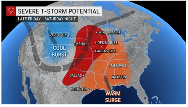
Accuweather.com map.
SIOUX FALLS, S.D. (KELO.com) — A large multifaceted storm is brewing for the nation’s midsection once again, AccuWeather meteorologists say.
The latest projections from the company’s team of forecasters indicate another round of severe weather is likely for parts of the Plains and Midwest, while the colder side of the storm could generate the third snowstorm in 10 days for parts of Montana and the Dakotas.
April has been a busy month not only in terms of severe thunderstorms but wintry conditions as well. The clash of winter and spring will continue again one week after a historic blizzard buried the northern Plains in feet of snow while a multiday severe weather threat roiled in the central and southern United States.
On Tuesday, April 12, the same storm that delivered blizzard conditions to portions of North Dakota also triggered a swath of severe weather from Kansas to Wisconsin. About a dozen tornadoes were reported along with nearly 200 incidents of large hail.

This image of the northern Pacific Ocean that was taken early Tuesday morning on April 19, 2022, shows a weak storm moving inland over the northwestern United States (right) and a large storm extending from Alaska’s Aleutian Islands (upper left) to several hundred miles west of the California coast (center). (NOAA/Goes-West)
This past weekend, another storm hit the northern Plains with several inches to a foot of snow and produced stiff winds that caused extensive blowing and drifting over a large part of North Dakota, northeastern Montana and northern Minnesota.
This incoming late-week storm for the Central states was located over the northern Pacific near Alaska’s Aleutian Islands as of Monday and is expected to roll into the Northwest later Wednesday, according to AccuWeather Chief On-Air Meteorologist Bernie Rayno.
The storm will re-organize over the Plains after crossing the interior West as warm air surges northward over much of the middle and eastern part of the nation.

The atmospheric setup on Friday and Saturday could spark severe storms from parts of the Dakotas, Minnesota and Wisconsin to areas farther south including Kansas, Oklahoma and central and western Texas. All facets of severe weather will be possible with the storms including high winds and large hail to localized flash flooding and tornadoes.
However, the setup that produced last week’s major storm versus this week’s is a bit different in that there is no evidence of a strong disturbance in the jet stream over the southern Plains.
“Storms over the southern Plains could be very isolated in nature as they erupt along a push of dry air from the deserts,” AccuWeather Lead Meteorologist Dan Pydynowski said.
That southern disturbance from last Tuesday sparked a great deal of severe weather from Texas to Louisiana and Arkansas. Those violent storms resulted in multiple injuries, at least one fatality and significant damage. With no strong southern disturbance competing for moisture this week, the door could be opened for severe thunderstorms to erupt farther to the north.
A greater concentration of severe weather is more likely over parts of the northern Plains and the Upper Midwest from Friday to Saturday, where developing thunderstorms are more likely to encounter surging moisture from the Gulf of Mexico. The severe weather risk will tend to shift from southwest to northeast across the Central states as the storm system strengthens near the Canada border and forces a strong cold front to spiral eastward.
Once the storm system moves onshore over the Northwest at midweek, where more meteorological data is available, a very good picture of the scope, area and timing of severe weather should become available, Rayno explained. At this early stage, it appears that portions of Iowa, Nebraska and Wisconsin could again be in the crosshairs of severe weather from late Friday to Saturday. The greatest chance of a couple of tornadoes during late Friday and Friday evening may extend from parts of South Dakota to Iowa.
On the anticipated storm’s cold side, heavy snow and strong winds are forecast for the end of the week as well. The exact track and strength of the storm will determine where the swath of heaviest snow and potential blizzard conditions unfold.
While winter savvy folks over the northern Plains can deal with the worst Mother Nature has in store, Old Man Winter has dished out more than 10 times the normal amount of snow for the first 17 days of April in the central and western part of North Dakota. Minot, North Dakota, has received nearly 42 inches of snow so far this month compared to a normal of 3.2 inches through Sunday, or 13 times that of average.

Initially, AccuWeather meteorologists expect the combination of snow and strong winds to extend over parts of central Manitoba, southern Saskatchewan and southeastern Alberta, Canada, this weekend. There is the potential for 1-2 feet (15-30 cm) of snow to fall in parts of this area, including the city of Regina, Saskatchewan.
Western portions of North Dakota, eastern Montana and perhaps as far to the south as northern Wyoming and northwestern South Dakota could also be hit with significant snow and wind from the storm from Friday to Saturday. A foot or more of snow could pile up in areas where all or mostly snow falls instead of rain or a rain and snow mix.
Motorists with travel plans through these areas should be prepared for major delays and road closures. Interstate 94 could be affected, as well as U.S. Routes 2, 12 and 85, and Canada Highways 1 and 16, forecasters say.
( AccuWeather senior meteorologist, contributed this report. It first appeared here on accuweather.com.)


