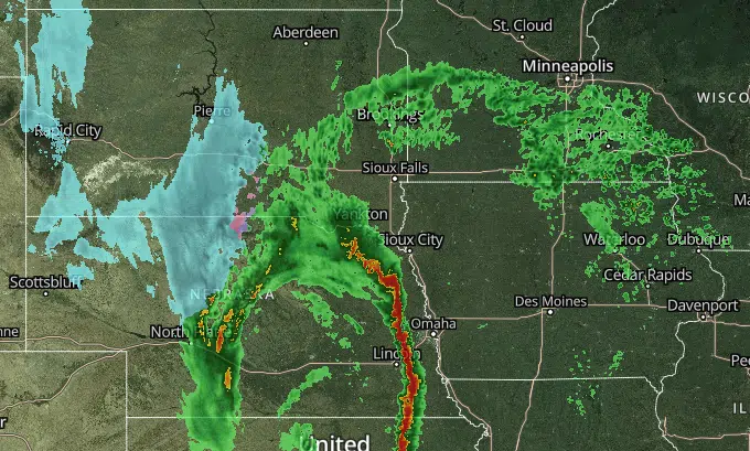
Screenshot at 3:55 p.m., 12/15/21, from kelo.com's radar provider.
SIOUX FALLS, S.D. (KELO.com) — AccuWeather expert meteorologists provide updates to media working on stories related to the severe weather risk.
According to AccuWeather Chief Meteorologist, Jonathan Porter:
“A dangerous severe weather situation is quickly evolving for Wednesday and Wednesday night across the Central United States including another extremely rare tornado threat in mid-December. A few days each year we ask people to be extra vigilant and be ready to take immediate action to protect themselves if weather warnings are issued for their communities – this is one of those days. this is one of those days.”
“An intense and unusually quick moving line of dangerous thunderstorms will develop late this afternoon and move to the east through the evening and overnight with the risk for destructive winds of over 80 mph in some places. In addition to the wind threat, tornadoes may also develop – a few of which could be particularly intense. The greatest risk for severe thunderstorms and a few tornadoes is expected to be across Iowa, southeastern Minnesota and western Wisconsin.”
“Severe destructive winds and tornadoes at night are a special concern and risk because at night most people are sleeping and less aware of what is happening nearby. It is incredibly important to have ways to get weather warnings tonight in the impacted areas. A great resource is the free AccuWeather app, download it and turn on push notifications so that weather warnings for your community are sent immediately to your phone.”
“Additionally, these storms are happening in a place where tornadoes and severe thunderstorms are unprecedented in mid-December. Call your family and friends in these areas to make sure they are aware of this threat and ready to take action if warnings are issued for their community. It is very helpful to have a plan in advance of where you will seek shelter in a basement or the lowest level of your home or business in an interior part of the building, away from windows. Thinking about this in advance is helpful because you then know what to do if a warning is issued and you only have a short time to react. These storms will be moving extremely quickly – as such, if you receive a warning, that’s the time to move to shelter.”
“Outside of the severe thunderstorm and tornado risk area, we have also been alerting about the risk for widespread damaging winds across much of the Plains and Great Lakes south through Colorado, Northern Arizona and Northern and Eastern New Mexico where gusts of 60 mph or more will be common with some wind gusts over 100 mph possible. This will result in significant travel delays and slowdowns in logistics operations, particularly problematic during the Holiday season and in a year with such significant existing supply chain challenges. The winds will also have the potential to damage homes and businesses and create power outages. Blowing dust will reduce visibilities in some communities and winds coupled with drought conditions especially in the Western Plains can create the risk for any small grassfire to exhibit rapid growth and unpredictable behavior in these conditions.”


Comments