AccuWeather graphic, 6/8/21.
SIOUX FALLS, S.D. (KELO.com) — AccuWeather meteorologists warn that the full spectrum of severe weather is possible, including tornadoes, from two rounds of violent storms taking aim at the northern Plains of the United States this week.
The severe weather will occur as two potent storm systems swing out from the northwestern U.S. and slide eastward across the northern tier of the Central states.
Even though most of the thunderstorms are expected to occur in the wide-open spaces in the region, there will be risks to livestock, crops, ranchers, small communities and even some larger cities.

In this image, captured on Tuesday morning, June 7, 2021, thunderstorms were wasting no time firing over parts of the Dakotas. (CIRA at Colorado State/GOES-East)
The first round is on the doorstep and poised to pack a punch through Tuesday night and will focus on multiple states in the North Central region.
Into Tuesday night, storms are forecast to erupt from east-central Montana and eastern Wyoming to the western and central parts of the Dakotas, western Nebraska and northeastern Colorado.
During Monday afternoon, a small cluster of brief tornadoes touched down in Weld County, Colorado, located in the north-central part of the state. Fortunately, the storms did not lead to any injuries, but they did cause minor property damage and sporadic power outages.
“This round of storms into Tuesday night, as well as a second round on Thursday, are likely to bring the full spectrum of severe weather, including tornadoes, to part of the North Central states,” AccuWeather Meteorologist Matt Benz said.

“In addition to the isolated tornado threat is the likelihood of storms with powerful wind gusts, as well as the potential for hail and flash flooding,” Benz continued.
Because of the strength of the Tuesday and Thursday storm systems and the wide open spaces in the region, wind gusts may reach 80 mph in some of the storms.
“Gusts with some of the storms on Thursday afternoon and night might even exceed 100 mph,” Benz added.
Hail could be quite large and exceeding the size of golf balls in some cases.
Even though much of the region is in need of rain, too much rain may fall too fast in some locations and result in isolated flash flooding. Conditions range from abnormally dry to that of exceptional drought, according to the United States Drought Monitor. Since Jan. 1, rainfall deficits ranged from 40 to 60% of average in a region that typically picks up a total of less than 8 inches through June 7.
And, it is not just the U.S. where the storms may strike a powerful blow. Adjacent areas of southern Saskatchewan and Manitoba are also forecast to face severe weather.
It is possible that some of the severe storms reach as far to the north as Regina, Saskatchewan, and Brandon and Winnipeg, Manitoba.

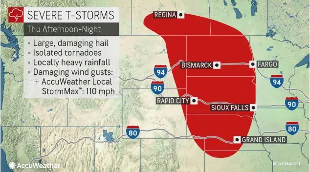
This image of the risk of thunderstorm severity for Thursday, June 10, is based on the forecast from the Storm Prediction Center (SPC).
Motorists on the highways, including interstates 25, 76, 80, 90 and 94, as well as Canada Highway 1, should keep alert for rapidly changing weather conditions on their travels. High winds in some of the storms alone may easily flip over trucks, campers and other high-profile vehicles.
Another threat from the storms, especially as they erupt and cruise through mountainous areas of the interior Northwest, will be the potential for lightning strikes with little or no rainfall. Lightning is a common natural mechanism to ignite wildfires. Both rounds of storms through Thursday have the potential to ignite blazes.
Some of the cities that could be hit by both rounds of storms include Rapid City and Pierre, South Dakota; Minot and Bismarck, North Dakota; Casper and Cheyenne, Wyoming; Scottsbluff, Nebraska; and Miles City and Glasgow, Montana.
In between both rounds of severe weather, a quiet day, relatively speaking, is likely over much of the region Wednesday. Still, there is the likelihood of spotty thunderstorms, which could still turn severe in some locations during the afternoon and evening hours Wednesday.
The two storm systems will attack a dome of heat that has delivered multiple days of 90-degree temperatures over a broad area of the North Central states. The persistence of the 90-degree weather is unusual for this early in the season, AccuWeather forecasters say, and some areas like the Twin Cities may take a run at records.

Through June 8, Minneapolis has had six days in a row with highs in the 90s, including two days in a row of record highs. Temperatures Friday, June, 4, climbed to 97 and broke the old record of 96 set in 1968. On Saturday, June 5, the temperature soared to 99 and shattered the old record of 92 set most in 1925 and 1911.
Highs are forecast to reach the 90s in Minneapolis and in much of the northern Plains and Upper Midwest through the end of the week. When the string finally breaks Saturday, with highs forecast to be in the upper 80s in the Twin Cities, there are likely to be nine days in a row of highs in the 90s.
Should the city hit these marks, it would tie for third place in longest streaks of 90-degree temperatures in a row set most recently in July 2006. The all-time record for consecutive 90-degree highs or greater was in July during the blistering summer of 1936 and the Dust Bowl Era. The city hits 90 an average of 14 times a year with the all-time record of 44 set during the summer of 1988.
Any break from the 90-degree heat over the weekend is likely to be brief in the wake of the late-week storm system. Temperatures are forecast to rebound back to hot levels by next week in much of the North Central states as surging heat from the West will expand eastward once again.
( AccuWeather senior meteorologist, contributed this report.)


Comments