AccuWeather map, 5/6/21.
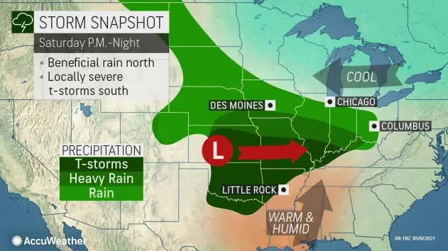
SIOUX FALLS, S.D. (KELO.com) —AccuWeather meteorologists have been monitoring a potent storm expected to move through the northwestern United States late this week before it eyes the central U.S. The system is forecast to produce a narrow zone of drenching rain in the Midwest with the risk of severe thunderstorms igniting farther south during Mother’s Day weekend.


The storm is expected to move slowly but steadily eastward from the Plains Saturday to the Ohio Valley on Mother’s Day. The exact track of the storm will determine the north and south extent of the rain.
It is likely the west to east band of rain from the storm will be rather narrow and there could be a fairly abrupt northern edge to the wet weather, AccuWeather Senior Meteorologist Brett Anderson said.
“Near the northern edge of the rain, some people may be drenched, while areas 50 miles farther to the north may not have a drop of rain the entire weekend,” Anderson explained.
The track of the storm has trended a bit farther south at midweek, compared to earlier this week.
“It now appears that the zone from northern Iowa to northern Illinois and southern Michigan may escape all or the majority of the storm’s rainfall,” Anderson said.
This means that cities such as Chicago and Detroit could be dry all or most of the weekend.
“At this time, the rain is likely to fall south of Interstate 80 and may be concentrated near the I-70 corridor of the Plains and Ohio Valley states,” AccuWeather Senior Meteorologist Matt Benz said.
Near I-70 over the Plains and between I-64 and I-70 in the Ohio Valley, there is the potential for 1-3 inches of rain to fall with locally higher amounts.
Rain is expected to break out over an approximate 1,000-mile-long swath during Saturday afternoon and evening from Colorado to Indiana and Kentucky. Within this zone, it may rain for 12-18 hours in some locations.
Central U.S. cities likely to be thoroughly soaked by the storm as it moves slowly eastward this weekend include Denver; Topeka, Kansas; St. Louis and Kansas City, Missouri; Indianapolis; Cincinnati and Columbus, Ohio; and Huntington, West Virginia.
“Only if the storm were to shift its track farther to the north again would the chance of rain increase in the corridor from Chicago to Detroit, and there is a chance the southward progress may even continue,” Benz said.
On Mother’s Day, as the back edge of the rain makes eastward progress over Colorado, northern Kansas, southern Nebraska, southern Iowa and northern Missouri, the leading edge of the rain is likely to advance across southern Ohio, Pennsylvania, northern West Virginia, northern Virginia and northern Maryland.
It is possible the rain will hold off until the afternoon or evening on Sunday in Delaware, New Jersey and southeastern New York state. This means that cities such as Philadelphia, Washington, D.C., Baltimore, New York City and Boston may be free of rain during most of the weekend.
“Only spotty showers may circulate southeastward from Canada in the wake of a storm that is forecast to move offshore of the Northeast states Friday night,” Benz said.
The best bet for outdoor plans around Pittsburgh appears to be Saturday, as rain may break out at any time on Mother’s Day. However, should the storm shift its track a bit farther to the south, then Indianapolis, Columbus and Pittsburgh could avoid most of the storm’s rainfall.
Just as the steadiest rain tends to fall near and north of the track of a storm system, thunderstorms tend to occur near and south of the center of low pressure of a storm. That will be no exception with the Mother’s Day weekend storm.
Since a surge of Gulf of Mexico moisture will accompany a significant rebound in temperature, and a dip in the jet stream will accompany the storm system, conditions may be conducive for the development of severe thunderstorms.
The jet stream dip tends to produce cold air aloft and helps to increase wind shear, which occurs when winds change suddenly in direction or speed with altitude. Both are ingredients for severe thunderstorms, and strong wind shear can fuel the development of rotating storms.
Areas at risk for severe weather during Saturday afternoon and night may focus on portions of central and eastern Kansas and western and central Missouri. However, thunderstorms, along with the risk of localized severe weather may extend as far to the south as central and eastern Oklahoma, western Arkansas and north-central Texas.
While the most common threats from the storms are likely to be strong wind gusts, torrential downpours with flash flooding and hail, the setup could produce a few isolated tornadoes as well.
On average, May is the peak month for tornadoes across the U.S., according to the National Weather Service Storm Prediction Center (SPC).
The AccuWeather long-range forecasting team is expecting a significant uptick in the number of severe weather incidents and tornadoes during May. Prior to the start of May, 2021 was running behind the recent three-year average of 386 tornadoes with a total of 291 preliminary tornado reports being tallied by the SPC.
As the storm moves along to the east on Mother’s Day, so will the likelihood of thunderstorms and the potential for severe weather. The risk of thunderstorms and possible severe weather will tend to focus from southeastern Missouri, Kentucky and southern West Virginia to much of Arkansas and Tennessee, northern Louisiana, northeastern Texas, northern Mississippi and northern Alabama.
The rainfall could be met with mixed reactions, since precipitation amounts have varied drastically across the region. There is a stark contrast in soil moisture over the Central states, according to the National Integrated Drought Information System.
In a swath from parts of north-central and west-central Texas to the Ohio Valley, top soil conditions are wet to very wet and saturated in some cases. This means the soil is not able to hold much moisture and may be prone to flooding from an all-day moderate rain or intense brief downpours that can be delivered during thunderstorms.
Conversely, from a drought-relief standpoint, some areas could stand more rainfall. Areas from Iowa to southern Wisconsin, northern Illinois, southern Michigan and northern Ohio could benefit from a thorough soaking, but the southward shift in the storm track may prevent needed rain from reaching these areas.
AccuWeather.com will continue to provide updates on the storm through the weekend and the AccuWeather app can keep people alert to any severe thunderstorm watches and warnings.
(AccuWeather contributed this report.)